
In the fast-evolving world of mining and resource management, Lidar Survey for Volume Calculation of Coal is becoming a game-changer. Traditional methods of volumetric analysis are often labor-intensive, time-consuming, and less accurate. With LiDAR-equipped drones, companies now have the ability to capture highly accurate 3D data of coal stockpiles and mining sites, improving operational efficiency and reducing costs.
What is a Drone LiDAR Survey?
LiDAR (Light Detection and Ranging) uses laser pulses to measure distances with extreme precision. When mounted on drones, this technology enables detailed topographic mapping of large areas—including rugged or dangerous terrains—within minutes. This makes it ideal for volume calculation of coal stockpiles, where precision and safety are paramount.

Why Choose Drone LiDAR for Coal Volume Calculation?
✅ High Accuracy
LiDAR sensors capture millions of data points, allowing for sub-centimeter level accuracy in volume estimation.
✅ Time Efficiency
Drone LiDAR surveys can be completed in a fraction of the time compared to manual surveying or ground-based methods.
✅ Safety First
Drones eliminate the need for surveyors to walk on unstable coal piles or operate in hazardous mining zones.
✅ Cost-Effective
Faster surveys, less manpower, and accurate data reduce the risk of miscalculation, saving operational costs in the long run.
How Drone LiDAR Survey Works in Coal Volume Estimation
- Flight Planning: The drone’s flight path is carefully planned using GPS-based navigation systems.
- Data Acquisition: The drone flies over the coal stockpile, collecting LiDAR data in real time.
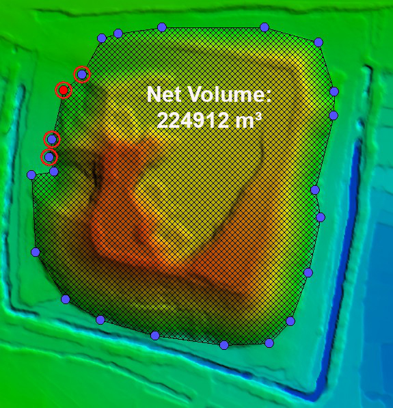
- Point Cloud Generation: The collect and processed into a 3D point cloud, representing the coal pile’s surface.
- Volume Calculation: Specialized software calculates the volume by comparing the scanned surface with a known base level.
- Report Generation: Detailed reports with measurements, contour lines, and volume analytics are delivered for review.
Use Cases:
- Thermal power plants
- Coal handling terminals
- Stockyard inventory audits
- Mines and logistics centers
Conclusion
A Drone LiDAR Survey for Coal Volume Calculation offers the perfect blend of speed, safety, and accuracy. Whether for monthly audits, real-time inventory tracking, or compliance reporting, this advanced technique ensures data you can trust—and decisions you can act on.